
搜索结果: 151-165 共查到“水文测量”相关记录814条 . 查询时间(5.672 秒)
A Spatial Technique for Estimating Streambank Erosion Based On Watershed Characteristics
Geographic Information System GIS watershed modeling streambank erosion sediment transport
2015/8/6
A GIS-based technique was developed for estimating streambank erosion rates for more accurately predicting total sediment loads at the watershed scale without the use of detailed field data. This tech...
Comparisons of local infiltration-excess, overland flow and associated erosion behaviour with river behaviour at the catchment scale
Hydrologic modeling overland flow erosion catchment scale
2015/8/6
Modeling overland flow and erosional behaviour is a very important scientific task today to prevent environmental impacts from human activities as well as physical disasters such as floods and deserti...
Modeling Groundwater Flow for the Delineation of Wellhead Protection Area around a Water-well at Nachole of Bangladesh
Groundwater Flow Modeling Zone of Contribution Zone of influence Wellhead Protection Area
2015/8/6
Delineation of wellhead protection area is an important component of groundwater contamination protection strategy to prevent probable environmental and health hazards. Modeling of ground water infilt...
Prediction of Ground Water Vulnerability using an Integrated GIS-based neuro-fuzzy techniques
Geographic Information System GIS
2015/8/6
There is a need to develop new modeling techniques that assess ground water vulnerability with less expensive data and which are robust when data are uncertain and incomplete. Incorporation of Geograp...
Surface water potential of the river Osun at Apoje sub-basin Nigeria
streamflow gauge heights Apoje sub-basin
2015/2/3
In order to archive the millennium goals of which water for all by the year 2015 is a major component; all efforts must be made to efficiently utilise the available water resources in various parts of...
Differences in the properties of the bottom sediments in the system of Wdzydze Lakes (Northern Poland)
humic acids lake bottom sediments
2015/2/3
The influence was determined of the anthropo-pressure on the changes in the properties of the bottom sediments, with particular consideration given to the properties of humic acids formed in the sedim...
Spatial variability of water repellency in pine forest soil
spatial variability water repellency WDPT test infiltration sorptivity
2015/2/3
The variability of water repellency of pine-forest arenic regosols and its influence on infiltration processes were measured in southwest Slovakia. The water drop penetration time (WDPT) tests of soil...
Technical and Institutional Evaluation of Geray Irrigation Scheme in West Gojjam Zone, Amhara Region, Ethiopia
Irrigation West Gojjam Zone Amhara Region Ethiopia Water User Associations WUA
2015/1/7
The technical and institutional performance evaluation of Geray Irrigation Scheme was made in order to identify management practices for implementation to improve the system operation and the performa...
Modeling Groundwater Flow for the Delineation of Wellhead Protection Area around a Water-well at Nachole of Bangladesh
Groundwater Flow Modeling Zone of Contribution Zone of influence Wellhead Protection Area
2015/1/4
Delineation of wellhead protection area is an important component of groundwater contamination protection strategy to prevent probable environmental and health hazards. Modeling of ground water infilt...
APPLICATION OF A RATIONAL MODEL IN GIS FOR FLOOD RISK ASSESSMENT IN ACCRA, GHANA
Flood Hazard Mapping GIS Integration
2014/11/12
Accra has been experiencing periodic flooding that affect properties and lives. The government
seeing the dangers involved has commissioned institutions such as Ministry of Works and
Housing, Town a...
Integrating Water Quality Modeling with GIS to Determine Management Strategies: A Study of Fort Gordon, GA
water quality modeling AGNPS (Agricultural Non-Point Source) GRASS (Geographic Resources Analysis Support System), GIS, land management, water resources
2014/11/12
Land managers of the Fort Gordon military installation in Augusta, GA were in need of a tool which
would predict the effects to water quality produced by changes in land use as well as predict
impac...
A COMPREHENSIVE GIS-BASED MODELING APPROACH FOR PREDICTING NUTRIENT LOADS IN WATERSHEDS
GIS watershed modeling TMDL nonpoint source pollution
2014/11/12
A comprehensive, GIS-based modeling approach was developed to enable accurate
prediction of nutrient loads in watersheds throughout the state of Pennsylvania; particularly those
watersheds for which...
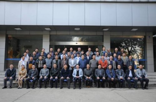
2014年11月4日,我所在会议中心举办了水文监测新技术及装备应用(青海・新疆)培训班。该班从11月4日培训至11月30日,有来自青海省水文水资源勘测局30名和新疆石河子玛纳斯河流域管理处的10名专业技术骨干参加了培训。培训班开幕式由何生荣副所长主持,蒋兆宏所长、青海省水文水资源勘测局严鹏局长、水利部水文局张建新处长等出席了开班仪式。

2014年10月30日,水利部南京水利水文自动化研究所在南京组织召开了“军用海洋水文装备定型试验系统潮汐标准测量系统”出所验收会议。
由来自南京水利科学研究院、江苏省水文水资源勘测局、解放军理工大学、第三十一试验训练基地、水利部南京水利水文自动化研究所等单位代表参加了会议,会议成立了的专家组成了验收专家组。专家组实地查看了实施现场、听取了项目实施情况汇报,并审阅了出所验收的相关资料,经讨论和审查...