
�������: 1-15 ���鵽����ѧ videos����ؼ�¼23�� . ��ѯʱ��(0.093 ��)
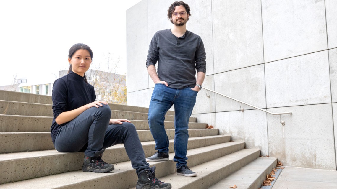
An app developed by Cornell researchers uses augmented reality to help users repeatedly capture images from the same location with a phone or tablet to make time-lapse videos �C without leaving a camer...
SEMANTIC INFORMATION EXTRACTION OF LANES BASED ON ONBOARD CAMERA VIDEOS
Lane Marking Detection Lane Semantic Recognition Lane Classification Onboard Camera Video Lane-Base d Road Network
2018/5/15
In the field of autonomous driving, semantic information of lanes is very important. This paper proposes a method of automatic detection of lanes and extraction of semantic information from onboard ca...
New NSF-funded videos highlight 'Human Water Cycle'
New NSF videos highlight Human Water Cycle
2017/2/16
Today, the National Science Foundation (NSF) and NBC Learn, the educational arm of NBC News, released an original video series that explores the connection between water, food and energ...
Reach in and touch objects in videos with ��Interactive Dynamic Video��
Reach touch objects videos Interactive Dynamic Video
2016/8/11
We learn a lot about objects by manipulating them: poking, pushing, prodding, and then seeing how they react.We obviously can��t do that with videos �� just try touching that cat video on your phone and...
MUTUAL COMPARATIVE FILTERING FOR CHANGE DETECTION IN VIDEOS WITH UNSTABLE ILLUMINATION CONDITIONS
Change detection moving object detection illumination changes mutual comparative filters
2016/7/27
In this paper we propose a new approach for change detection and moving objects detection in videos with unstable, abrupt illumination changes. This approach is based on mutual comparative filters and...
We present an interactive texture painting system that allows the user to author digital images by painting with
a palette of input textures. At the core of our system is an interactive texture synth...
First-ever videos show how heat moves through materials at the nanoscale and speed of sound
First-ever videos heat moves materials nanoscale speed of sound
2016/4/25
Using a state-of-the-art ultrafast electron microscope, University of Minnesota researchers have recorded the first-ever videos showing how heat moves through materials at the nanoscale traveling at t...
MOTION DETECTION BY CLASSIFICATION OF LOCAL STRUCTURES IN AIRBORNE THERMAL VIDEOS
Detection of moving objects classification sensor pose estimation
2015/8/7
In this paper we present a method to efficiently detect moving objects namely vehicles in airborne thermal videos. The motion of the sensor is estimated from the optical flow using projective planar h...
CLASSIFICATION OF LOCAL STRUCTURES IN AIRBORNE THERMAL VIDEOS FOR VEHICLE DETECTION
Detection of vehicles interest points classification
2015/8/3
In this paper airborne thermal videos are used to detect vehicles. The movement of the camera is estimated from the optical flow using projective planar homographies as transformation model. A three l...
GOOD SAMPLE CONSENSUS ESTIMATION OF 2D-HOMOGRAPHIES FOR VEHICLE MOVEMENT DETECTION FROM THERMAL VIDEOS
Infrared surveillance Machine vision Object recognition
2015/5/18
In this contribution we describe a method to assess the activity of vehicles based on airborne image sequences taken by an infrared
camera. Active vehicles often appear as a configuration of a dark a...
Incorporating Boltzmann Machine Priors for Semantic Labeling in Images and Videos
computer vision machine learning image segmentation deep learning deep models
2014/12/18
Semantic labeling is the task of assigning category labels to regions in an image. For example, a scene may consist of regions corresponding to categories such as sky, water, and ground, or parts of a...
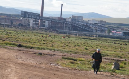
The dramatic expansion of Mongolian mine sites from initial diggings to their present size has been captured using satellite imagery for the first time by researchers at The University of Queensland��s...
STITCHING LARGE MAPS FROM VIDEOS TAKEN BY A CAMERA MOVING CLOSE OVER A PLANE USING HOMOGRAPHY DECOMPOSITION
Panorama stitching planar homographies homography decomposition underwater mapping UAV surveillance
2014/5/8
For applications such as underwater monitoring a platform with a camera will be moving close to a large roughly planar scene. The idea to map the scene by stitching a panorama using planar homographie...
USING STEREO VISION TO SUPPORT THE AUTOMATED ANALYSIS OF SURVEILLANCE VIDEOS
Image Sequences Stereoscopic Vision Image Matching
2014/4/28
Video surveillance systems are no longer a collection of independent cameras, manually controlled by human operators. Instead, smart sensor networks are developed, able to fulfil certain tasks on thei...
CONTEXT-BASED URBAN TERRAIN RECONSTRUCTION FROM UAV-VIDEOS FOR GEOINFORMATION APPLICATIONS
UAVs, Photogrammetry Sensor Orientation Urban Terrain Reconstruction
2014/5/9
Urban terrain reconstruction has many applications in areas of civil engineering, urban planning, surveillance and defense research.
Therefore the needs of covering ad-hoc demand and performing a cl...
�й��о����������а�-��
- ���ڼ���...
�й�ѧ���ڿ����а�-��
- ���ڼ���...
�����ѧ���л������а�-��
- ���ڼ���...
�й���ѧ���а�-��
- ���ڼ���...
�ˡ���-ƪ
- ���ڼ���...
�Ρ���-ƪ
- ���ڼ���...
��������-ƪ
- ���ڼ���...
�������� -ƪ
- ���ڼ���...
֪ʶҪ��-ƪ
- ���ڼ���...
���ʶ�̬-ƪ
- ���ڼ���...
��������-ƪ
- ���ڼ���...
ѧ��ָ��-ƪ
- ���ڼ���...
ѧ��վ��-ƪ
- ���ڼ���...