
�������: 1-15 ���鵽����ѧ software����ؼ�¼271�� . ��ѯʱ��(0.578 ��)

�Ϸʹ�ҵ��ѧ���������ϢѧԺ���˹�����ѧԺ��˶ʿ���ڹ����������������ڿ���IEEE Transactions on Software Engineering����CCF A�ࣩ�Ϸ��������о��ɹ���ͼ��
�Ϸʹ�ҵ��ѧ���������ϢѧԺ���˹�����ѧԺ�� ������������ IEEE Transactions on Software Engineering ��������
2023/1/7
���գ��Ϸʹ�ҵ��ѧ���������ϢѧԺ˶ʿ�о������ں���־ʤ�����ġ�New Reliability-Driven Bounds for Architecture-Based Multi-objective Testing Resource Allocation ������������������ʶ����ڿ���IEEE Transactions on Software Engineering (TSE)�����߷�����htt...
As a postdoctoral research associate in the lab of BTI faculty member Frank Schroeder, Max Helf saw his labmates continually struggle when they were analyzing data. So, he decided to do something abou...
If deep space exploration is to become a reality, humans will need to be as self-sufficient as possible. Since ordering supplies from Earth won��t be practical, the astronauts will have to fabricate th...
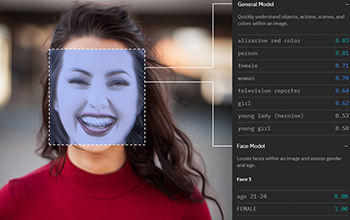
Facial recognition software has a gender problem��ͼ��
Facial recognition software gender problem
2019/11/5
With a brief glance, facial recognition software can categorize gender with remarkable accuracy. But if that face belongs to a transgender person, such systems get it wrong more than one third of the ...
OPEN SOURCE SOFTWARE AND OPEN EDUCATIONAL MATERIAL ON LAND COVER MAPS INTERCOMPARISON AND VALIDATION
Capacity Building Education Land Cover Open Access Open Source Validation
2018/11/9
Land Cover (LC) maps represent key resources to understand, model and address many global and local dynamics affecting our planet. They are usually derived from the classification of satellite imagery...
TESTING THE IMPACT OF 2D GENERALISATION ON 3D MODELS �C EXPLORING ANALYSIS OPTIONS WITH AN OFF-THE-SHELF SOFTWARE PACKAGE
3D generalisation 3D models 3D buildings simplification aggregation performance
2018/11/9
Popularity and diverse use of 3D city models has increased exponentially in the past few years, providing a more realistic impression and understanding of cities. Often, 3D city models are created by ...
DESIGN AND APPLICATIONS OF RAPID IMAGE TILE PRODUCING SOFTWARE BASED ON MOSAIC DATASET
Image Tile Mosaic Dataset Cluster Tile Producing Quality Checking
2018/5/16
Map tile technology is widely used in web geographic information services. How to efficiently produce map tiles is key technology for rapid service of images on web. In this paper, a rapid producing s...
USE OF FISHEYE PARROT BEBOP 2 IMAGES FOR 3D MODELLING USING COMMERCIAL PHOTOGRAMMETRIC SOFTWARE
Fisheye Distortions Camera Calibration Parrot Bebop 3D modelling Agisoft PhotoScan Pix4D Mapper
2018/6/4
Fisheye camera installed on-board mass market UAS are becoming very popular and it is more and more frequent the use of such platforms for photogrammetric purposes. The interest of wide-angles images ...
INVESTIGATIONS ON THE BUNDLE ADJUSTMENT RESULTS FROM SFM-BASED SOFTWARE FOR MAPPING PURPOSES
bundle adjustment photogrammetry mapping DBAT Inpho ERDAS, PhotoScan
2018/6/4
Since its first inception, aerial photography has been used for topographic mapping. Large-scale aerial photography contributed to the creation of many of the topographic maps around the world. In Ind...
3D CULTURAL HERITAGE DOCUMENTATION: A COMPARISON BETWEEN DIFFERENT PHOTOGRAMMETRIC SOFTWARE AND THEIR PRODUCTS
Cultural Heritage Data Repositories Emergency Photogrammetric workflow Photogrammetric software comparison Dense cloud validation Terrestrial Laser Scanner
2018/6/4
The conservation of Cultural Heritage depends on the availability of means and resources and, consequently, on the possibility to make effective operations of data acquisition. In facts, on the one ha...
4D-SFM PHOTOGRAMMETRY FOR MONITORING SEDIMENT DYNAMICS IN A DEBRIS-FLOW CATCHMENT: SOFTWARE TESTING AND RESULTS COMPARISON
4D-SfM Photogrammetry Sediment dynamics monitoring Software comparison Debris flow hazard
2018/6/4
In recent years, the combination of Structure-from-Motion (SfM) algorithms and UAV-based aerial images has revolutionised 3D topographic surveys for natural environment monitoring, offering low-cost, ...
DIGITAL IMAGE CORRELATION FROM COMMERCIAL TO FOS SOFTWARE: A MATURE TECHNIQUE FOR FULL-FIELD DISPLACEMENT MEASUREMENTS
Close range photogrammetry Digital Image Correlation Full-field displacement measurement Commercial and Free and Open Source Software
2018/6/4
In the last few decades, there has been a growing interest in studying non-contact methods for full-field displacement and strain measurement. Among such techniques, Digital Image Correlation (DIC) ha...
������ѧ����ѧԺ��־���Ŷ��й������ع����о�������IEEE Transactions on Software Engineering����
������ѧ����ѧԺ ��־�� �����ع� IEEE Transactions on Software Engineering
2022/3/11
���գ�����ѧԺ��־�������о��Ŷӵ��й������ع��Զ����������о��������������һ�ڵ�IEEE�������̻㿯(IEEE Transactions on Software Engineering)�����ĵĵ�һ����Ϊ��־�����ڵIJ�ʿ�о�����Ө��Automatic Software Refactoring via Weighted Clustering in Method-level Networks, IE...
3D MODELLING BY LOW-COST RANGE CAMERA: SOFTWARE EVALUATION AND COMPARISON
Range camera Occipital Structure SensorTM 3D modelling software comparison
2018/3/6
The aim of this work is to present a comparison among three software applications currently available for the Occipital Structure SensorTM; all these software were developed for collecting 3D models o...

Accelerating the Mobile Web����Vroom��'Software Could Double its Speed��ͼ��
accelerating the mobile web vroom software double its speed
2017/9/5
Despite that most web traffic today comes from smartphones and tablets, the mobile web remains inconveniently slow. Even on fast 4G networks, a page takes 14 seconds to load on average�Can eternity in ...
�й��о����������а�-��
- ���ڼ���...
�й�ѧ���ڿ����а�-��
- ���ڼ���...
�����ѧ���л������а�-��
- ���ڼ���...
�й���ѧ���а�-��
- ���ڼ���...
�ˡ���-ƪ
- ���ڼ���...
�Ρ���-ƪ
- ���ڼ���...
��������-ƪ
- ���ڼ���...
�������� -ƪ
- ���ڼ���...
֪ʶҪ��-ƪ
- ���ڼ���...
���ʶ�̬-ƪ
- ���ڼ���...
��������-ƪ
- ���ڼ���...
ѧ��ָ��-ƪ
- ���ڼ���...
ѧ��վ��-ƪ
- ���ڼ���...