
�������: 1-15 ���鵽������ѧ based����ؼ�¼102�� . ��ѯʱ��(0.274 ��)

�й����ʴ�ѧ��ѧ������չԺ����������ʿ����,�̽����ȵؿ�ѧԺ 2018, FRACTALS-COMPLEX GEOMETR��ͼ��Y PATTERNS AND SCALING IN NATURE AND SOCIETY, A NEW METHOD FOR CALCULATING FRACTAL DIMENSIONS OF POROUS MEDIA BASED ON PORE SIZE DISTRIBUTION
���Σ�ëϸ�ܣ�����ģ����㣻����ʣ���϶�ռ䣻�����ȣ�����ά��
2021/10/21
��ǰ��2018����ʿ�о����������ڹ���ѧ���ڿ������Ρ�������Ϊ��һ�ֻ��ڶ���ʿ��ֲ��ķ���ά���¼��㷽���������ģ���ѡMathematicsѧ������߱������ġ��ڸ������У������������һ�ֻ��ڷ���ëϸ�ܼ���ļ������ʿ�϶�ռ�������ȷ���ά�����·�����
��ɭ,�����* ����ԴѧԺ������������Դ�������ص�ʵ����. AAPG Bulletin, 2019. Seismic-based identification and stage analysis of overlapped compound sedimentary units in rifted lacustrine basins: An example from the Bozhong sag, Bohai Bay Basin, China
��ά���������ݣ���������̽
2021/10/20
���գ��й����ʴ�ѧ��ԴѧԺ����ν����Ŷ��ڹ��ʶ���ʯ�͵����ڿ���AAPG Bulletin���Ͽ����о��ɹ���ϵͳ�����˻�����ά�������ϵ�½����ݺ��踴�ϳ�����ʶ���ڴλ��ַ��������Բ�������ض�Ӫ����ͱ�״��������Ϊʵ����������������Ϊָ������ϸ�����˱�״���������ڴε�����ṹ��ƽ��չ����̬���ؽ����������ݻ����̡��о��ɹ���½����ݺ��������پ����������㾫ϸ�̻���������Ȧ�����۾�����Ҫ����...
�й����ʴ�ѧ��ѧ������չԺ���������У��·��ȣ���ԴѧԺ/������������Դ�������ص�ʵ����. Energy(December 2020), The effect of tectonic deformation and preservation condition on the shale pore structure using adsorption-based textural quantification and 3D image observation
�������ã������������л��ʣ�ҳ�ң����ף���϶�������ݻ�
2021/10/15
���գ��й����ʴ�ѧ��ԴѧԺ��ʿ���������ڹ���������Դ����ѧ�ڿ���Energy���Ͽ����о��ɹ����óɹ���Ҫ��ʾ�˹������úͱ��������Ը��л���ҳ������϶�����ݻ��Ŀ������ã�̽���˲�ͬ��϶�ṹ������ҳ�Ҵ���ѹ�Ѹ���Ч����
�й����ʴ�ѧ��ѧ������չԺƽ��ΰ,�º캺��.��ԴѧԺ/������������Դ�������ص�ʵ����.AAPG Bulletin(2020).Quantitatively predicting the thermal maturity of oil trapped in fluid inclusions based on fluorescence and molecular geochemical data of oil inclusions in the Dongying depression, Bohai Bay Basin, China
ӫ�⣻����Լ������һ�ڴΣ��Ͱ�������ӣ��ɷ֣���������
2021/10/15
���գ��й����ʴ�ѧ��ԴѧԺ�º캺�����Ŷ�ƽ��ΰ�����ڹ��ʶ���ʯ�͵����ڿ���AAPG Bulletin���Ͽ����о��ɹ�������ӫ�����Լ���ĵ�һ�ڴ��Ͱ�������ӳɷַ��������������Դ������������ӫ���ݻ�ģ�ͣ������˶�Ӫ�����Ͱ�����ӫ����ɫ�����ȳ���ȵĶ�����ϵ��ʵ���������Ͱ�����ӫ�������Ե����Ͱ������ȳ���ȵĶ���Ԥ�⡣
�й����ʴ�ѧ��ѧ������չԺ��������ά���ȣ���ԴѧԺ. Rock Mechanics and Rock Engineering��Geometry and Filling Features of Hydraulic Fractures in Coalbed Methane Reservoirs based on Subsurface Observations
ú������ѹ�ѣ��ѷ���̬������������
2021/10/15
���ڣ��й����ʴ�ѧ��ԴѧԺ����ά�����Ŷ�����ʯ��ѧ���������ڿ���Rock Mechanics and Rock Engineering���Ϸ�����Ϊ��Geometry and Filling Features of Hydraulic Fractures in Coalbed Methane Reservoirs based on Subsurface Observations�����о��ɹ�������ͨ��...
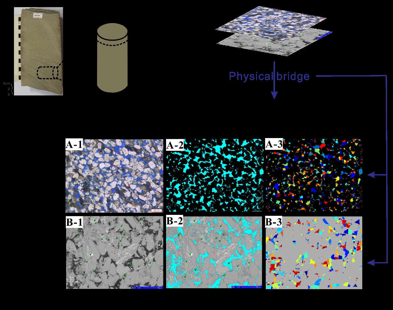
�й����ʴ�ѧ��ѧ������չԺ��Т��(��ʿ�о���),Ҧ����* ��, ��ԴѧԺ/������������Դ�������ص�ʵ���� JGR-Solid Earth, 2019, Capillary Pressure Curve Determination Based on a 2�\D Cross�\Section Analysis Via Fractal Geometry: A Bridge Between 2�\D and 3�\D Pore Structure of Porous Media��ͼ��
��ά������ʣ���ά�����˻���
2021/10/20
���գ����ʵ�������Nature Index�ڿ���Journal of Geophysical Research: Solid Earth���������й����ʴ�ѧ���ڶ���ʶ�ά����ά֮�����˻�������������о��ɹ������ڷ��μ��εĶ�ά�������ȷ��ëϸ��ѹ�����ߣ�����ʵĶ�ά����ά��϶�ṹ֮�������(Capillary Pressure Curve Determination Based on a 2-...
ESTIMATION OF INSTANTANEOUS EVAPOTRANSPIRATION USING REMOTE SENSING BASED ENERGY BALANCE TECHNIQUE OVER PARTS OF NORTH INDIA
Evapotranspiration Energy Balance Approach Remote Sensing Sensible heat flux
2019/2/27
Evapotranspiration (ET) is an essential element of the hydrological cycle and plays a significant role in regional and global climate through the hydrological circulation. Estimation and monitoring of...
HIGH-RESOLUTION ENHANCED PRODUCT BASED ON SMAP ACTIVE-PASSIVE APPROACH USING SENTINEL 1A AND 1B SAR DATA
soil moisture microwave remote sensing active-passive algorithm SMAP Sentinel-1A -1B
2019/2/27
SMAP project released a new enhanced high-resolution (3km) soil moisture active-passive product. This product is obtained by combining the SMAP radiometer data and the Sentinel-1A and -1B Synthetic Ap...
LANDSLIDE HAZARD ZONATION IN AND AROUND KEDARNATH REGION AND ITS VALIDATION BASED ON REAL TIME KEDARNATH DISASTER USING GEOSPATIAL TECHNIQUES
Landslide Hazard Zonation GIS Orthorectification Drainage Density Geomorphology
2019/2/28
Landslides are one of the frequently happening disasters in this hilly state of Uttarakhand which accounts to the loss of lives and property every year especially during the rainy season which lead to...
SUPERPIXEL BASED FACTOR ANALYSIS AND TARGET TRANSFORMATION METHOD FOR MARTIAN MINERALS DETECTION
Superpixel Factor Analysis Target Transformation Minerals detection Mars
2018/5/15
The Factor analysis and target transformation (FATT) is an effective method to test for the presence of particular mineral on Martian surface. It has been used both in thermal infrared (Thermal Emissi...
STUDY ON THE DISTRIBUTION OF GEOLOGICAL HAZARDS BASED ON FRACTAL CHARACTERISTICS �C A CASE STUDY OF DACHUAN DISTRICT
Geologic Hazard Fractal Theory Fractal Dimension Self Correlation Risk Zoning
2018/5/15
It is a complicated process to analyze the cause of geological hazard. Through the analysis function of GIS software, 250 landslides were randomly selected from 395 landslide hazards in the study area...
EDGE-BASED LOCALLY AGGREGATED DESCRIPTORS FOR IMAGE CLUSTERING
Edge feature points Local feature aggregation Global image descriptors Image clustering
2018/5/11
The current global image descriptors are mostly obtained by using the local image features aggregation, which fail to take full account of the details of the image, resulting in the loss of the semant...
THE RESEARCH ON ELEVATION CHANGE OF ANTARCTIC ICE SHEET BASED ON CRYOSAT-2 ALIMETER
Antarctic Ice Sheet, Cryosat-2,Satellite Altimetry,DEM, Crossover Adjustment,Kriging Interpolation, Intersection
2018/5/15
In this paper, the Cryosat-2 altimeter data distributed by the ESA, and these data are processed to extract the information of the elevation change of the Antarctic ice sheet from 2010 to 2017. Firstl...
GRASSLAND NPP MONITORING BASED ON MULTI-SOURCE REMOTE SENSING DATA FUSION
Multi-source remote sensing Data fusion Net primary productivity Carnegie-Ames-Stanford Approach model
2018/5/11
Vegetation is an important part of the terrestrial ecosystem. It plays an important role in the energy and material exchange of the ground-atmosphere system and is a key part of the global carbon cycl...
STUDY ON KARST INFORMATION IDENTIFICATION OF QIANDONGNAN PREFECTURE BASED ON RS AND GIS TECHNOLOGY
Karst Landsat-5 TM Image RS+DEM Slope Karst Rocky Desertification
2018/5/16
Karst area is a pure natural resource base, at the same time, due to the special geological environment; there are droughts and floods alternating with frequent karst collapse, rocky desertification a...
�й��о����������а�-��
- ���ڼ���...
�й�ѧ���ڿ����а�-��
- ���ڼ���...
�����ѧ���л������а�-��
- ���ڼ���...
�й���ѧ���а�-��
- ���ڼ���...
�ˡ���-ƪ
- ���ڼ���...
�Ρ���-ƪ
- ���ڼ���...
��������-ƪ
- ���ڼ���...
�������� -ƪ
- ���ڼ���...
֪ʶҪ��-ƪ
- ���ڼ���...
���ʶ�̬-ƪ
- ���ڼ���...
��������-ƪ
- ���ڼ���...
ѧ��ָ��-ƪ
- ���ڼ���...
ѧ��վ��-ƪ
- ���ڼ���...