
搜索结果: 151-165 共查到“全息技术和三维成像”相关记录678条 . 查询时间(0.763 秒)
3D MODELLING AND MEDIEVAL LIGHTING RECONSTRUCTION FOR RUPESTRIAN CHURCHES
Laser scanning Photogrammetry 3D Modelling Lighting analysis
2019/3/2
The aim of this research is to define a method, able to analyse the systems of illumination in the medieval period, through a 3D virtual model reconstruction. It specifically needs to deepen the inter...
GENERATIVE ADVERSARIAL NETWORKS FOR SINGLE PHOTO 3D RECONSTRUCTION
generative adversarial networks deep convolutional neural networks
2019/3/2
Fast but precise 3D reconstructions of cultural heritage scenes are becoming very requested in the archaeology and architecture. While modern multi-image 3D reconstruction approaches provide impressiv...
HIGH QUALITY TEXTURE MAPPING PROCESS AIMED AT THE OPTIMIZATION OF 3D STRUCTURED LIGHT MODELS
Texture Mapping Structured Light Scanning Restoration 3D Visualization
2019/3/2
This article presents the evaluation of a pipeline to develop a high-quality texture mapping implementation which makes it possible to carry out a semantic high-quality 3D textured model. Due to geome...
王晏民,男,1958年出生。主要从事工作:科研工作、教学工作和教育管理。目前主要从事三维测量与三维地理信息系统研究,研究方向为激光雷达与摄影测量结合精细三维测量与建模、精细三维空间数据管理、建筑遗产数字化保护、精密工程测量。发表相关论文86篇,撰写专著1部,教材1部;获国家级科技进步奖二等奖1项、省部级科技奖4项;获省部级教学成果一等奖1项、二等奖2项;获授权国家发明专利6项;获软件著作权5项。
TO ACHIEVE REAL IMMERSION: THE 3D VIRTUAL AND PHYSICAL RECONSTRUCTION OF CAVE 3 AND CAVE 12 OF YUNGANG GROTTOES
cascade SfM robust detailed MVS 3D printing replica cave
2019/3/1
s the 3D laser scanning and photogrammetry technologies continue to mature, more and more applications founded in numerous areas. The realistic 3D models are mainly adopted for digital display uses, s...
DEVELOPMENT OF VIRTUAL REALITY APPLICATION FOR CULTURAL HERITAGE VISUALIZATION FROM MULTI-SOURCE 3D DATA
Virtual Reality Visualization Cultural heritage Multi-source data
2019/3/1
Immersive technologies like Virtual or Augmented Reality (VR/AR) are lately becoming more and more popular in wide range of scientific applications. These technologies provide the most immersive way t...
ACCURACY ASSESSMENT OF 3D MODELS GENERATED FROM GOOGLE STREET VIEW IMAGERY
Spherical Photogrammetry Equi-rectangular Panoramas Accuracy
2019/3/1
Google Street View is a technology implemented in several Google services/applications (e.g. Google Maps, Google Earth) which provides the user, interested in viewing a particular location on the map,...
INTEGRATED 3D SURVEY AND DIAGNOSTIC ANALYSIS FOR THE BUILDING ENGINEERING: THE FORMER KINDERGARTEN SAN FILIPPO NERI IN DALMINE
Dalmine Former kindergarten San Filippo Neri Integrated Architectural Survey
2019/3/1
The paper aims to emphasise the positive contribution that the 3D laser scanning and digital photogrammetry survey, integrated with diagnostic analysis techniques, can make in the field of constructio...

江文萍,博士生导师,副教授。2014.7-2015.7 美国佐治亚大学地理系访问学者,2000.09-2006.06 武汉大学博士,1996.09-1999.06 武汉测绘科技大学硕士。研究工作经历:2006.11月-至今,武汉大学,资源与环境科学学院,任副教授,2000.11-2006.10,武汉大学,资源与环境科学学院,任讲师。主要研究方向为:地理信息三维可视化、数字地貌晕渲。教学情况:本科课...
杨光辉,1997.09-2001.07烟台大学机械设计制造及自动化专业,获学士学位、2001.09-2007.07北京科技大学机械工程学院机械设计及理论专业,获博士学位(硕博连读)、2007.07-2012.07北京科技大学机械工程学院,讲师、2011.11-2014.01北京科技大学管理科学与工程,博士后(联合培养)、2012.08-至今北京科技大学机械工程学院,副教授。先后主持或参与多项国家级...
华中科技大学物理学院超快光学团队阿秒光电子全息研究取得进展
华中科技大学物理学院 超快光学 阿秒光电子全息
2019/1/18
2018年12月21日,物理学院陆培祥教授领导的超快光学团队在《物理评论快报》上发表了题为《利用阿秒光电子全息测量场强电离时间》(Determination of the Ionization Time Using Attosecond Photoelectron Interferometry)的文章,他们提出并演示了利用光电子全息精确测量强激光场中原子隧穿电离的时间。一般而言,在强激光场的作用下...
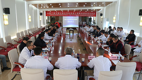
人体三维可视化联合实验室成立(图)
人体三维 可视化 联合实验室
2018/12/28
2018年12月18日,医学物理中心与安徽紫薇帝星数字科技有限公司正式达成合作协议,双方一致同意共同建立人体三维可视化联合实验室。
山东大学科技期刊社四期刊获中国高校期刊奖励
山东大学科技期刊社 四期刊 中国高校 期刊奖励
2018/11/20
2018年11月5日,中国高校科技期刊研究会公布了2018年度全国高校“杰出・百佳・优秀科技期刊”评选结果。山东大学科技期刊社编辑出版的《山东大学学报(理学版)》被评为“中国高校百佳科技期刊”;《山东大学学报(医学版)》《山东大学学报(工学版)》《山东大学耳鼻喉眼学报》被评为“中国高校优秀科技期刊”。近年来,科技期刊社紧紧围绕学校“双一流”建设,以创建“名刊强社”为目标,认真谋划发展蓝图,实施“期...
UNMANNED AERIAL VEHICLE (UAV) SURVEY-ASSISTED 3D MANGROVE TREE MODELING
Mangroves 3D Visualization 3D Modeling Unmanned Aerial Vehicle Assistive Modeling
2018/11/8
3D visualization is a tool that supports geospatial analysis through the application of scientific information. It enhances the quality of standard photography and can be used in many applications. Th...