
�������: 31-45 ���鵽����ѧ Deep����ؼ�¼499�� . ��ѯʱ��(0.682 ��)

��鹹��ѧ˵Ϊ���͵ر��۲�ļ���ȫ�����������ṩ�˶���ѧ���ƣ��磬�������˶����ƣ�Զ��˴˵Ĵ�½��������ƹ���������������γɣ��Լ���½������ͬ�ض����������ԭ��ȵȡ���Щ�˶�ͨ������½�����ӿ�ֱ��Ӧ�İ�鸩��ͺ�������ʵ�֡�����˶��������ǵ������ɵġ�
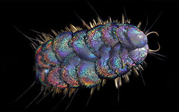
Scientists discover four new species of deep-sea scale worms��ͼ��
Scientists new species deep-sea scale worms
2020/5/22
National Science Foundation-funded researchers at the Scripps Institution of Oceanography have discovered four new species of scale worms from deep-sea habitats in the eastern Pacific Ocean....
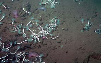
Deep-sea worms and bacteria team up to harvest methane��ͼ��
Deep-sea worms bacteria team harvest methane
2020/4/10
Scientists at Caltech and Occidental College have discovered a methane-fueled symbiosis between worms and bacteria at the bottom of the sea, shedding new light on the ecology of deep-sea env...
Study weighs deep-sea mining's impact on microbes��ͼ��
Study weighs deep-sea mining impact microbes
2020/2/20
The essential roles microbes play in deep-sea ecosystems are at risk from the potential environmental impacts of mining, a new paper in Limnology and Oceanography reports. The NSF-funded study reviews...

Hurricane Nicole sheds light on how storms impact the deep ocean��ͼ��
Hurricane Nicole sheds storms impact deep ocean
2019/10/18
In early October 2016, tropical storm Nicole formed in the middle of the Atlantic Ocean. It roamed for six days, reaching Category 4 hurricane status with powerful 140 miles per hour winds, before hit...

From Research to Carbon Charge, Nobel Prize Winner Has Deep Influence at F&ES
Carbon Charge Nobel Prize William Nordhaus Climate change
2019/9/19
This week William Nordhaus, Sterling Professor of Economics at Yale, won the Nobel Prize. At the Yale School of Forestry & Environmental Studies, where he holds a secondary appointment, his research a...

Deep-sea sediments lead to new understanding of solar system��ͼ��
Deep-sea sediments new understanding solar system
2019/10/18
A day is the time for Earth to make one complete rotation on its axis, and a year is one revolution around the Sun -- reminders that basic units of time and periods on Earth are intimately linked to o...

Engineering improvements to deep brain stimulation��ͼ��
Engineering improvements deep brain stimulation
2019/10/22
This University of Washington research is advancing deep brain stimulation, or DBS, which is used to treat people with essential tremor, Parkinson's disease and other conditions. A team at the Center ...

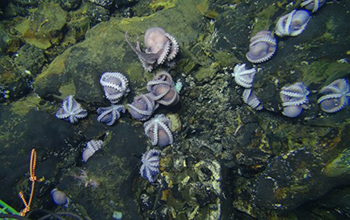
Deep-ocean vents fuel massive phytoplankton blooms��ͼ��
Deep-ocean vents fuel phytoplankton blooms
2019/10/28
Researchers at Stanford University have found an aquatic highway that releases nutrients from within the Earth and ferries them up to surface waters off the coast of Antarctica. There the nutrients st...
�й����ʴ�ѧ��ѧ������չԺ���ʹ�� GPMR�����ص�ʵ����. Earth-Science Reviews, May 2019, Deep learning and its application in geochemical mapping
��Դ����ѧ�ռ䣻���ݣ��ھ��о��ȵ㣻ǰ��
2021/10/20
���գ��й����ʴ�ѧ���ʹ���������Դ�����ص�ʵ�����ʹ�����Ŷӵ������о��ɹ���Earth-Science Reviews�� ������Deep learning and its application in geochemical mapping�����ĵ�һ��ͨѶ����Ϊ���ʹ���ڡ�

Major deep carbon sink linked to microbes at volcanic island chains��ͼ��
deep carbon sink microbes volcanic island chains
2019/11/22
As much as 19 percent more carbon dioxide than previously believed is removed naturally and stored deep underground in seafloor trenches near island chains of volcanoes, according to a study in the jo...
COMPARATIVE STUDY ON DEEP NEURAL NETWORK MODELS FOR CROP CLASSIFICATION USING TIME SERIES POLSAR AND OPTICAL DATA
Deep neural networks CNNs LSTMs ConvLSTMs Crop classification
2019/2/28
Crop classification is an important task in many crop monitoring applications. Satellite remote sensing has provided easy, reliable, and fast approaches to crop classification task. In this study, a c...
�й����ʴ�ѧ��ѧ������չԺ����, ����ʱ��GPMR�����ص�ʵ���� Earth and Planetary Science Letters, Available online 6 June 2018. Mercury anomalies across the end Permian mass extinction in South China from shallow and deep water depositional environments
����������ͬλ�أ�����ѧ���ֶΣ�֤ʵ������������������ǻ�ɽ
2021/10/21
���գ��й����ʴ�ѧ���ʹ���������Դ�����ص�ʵ��������ʱ�����Ŷ��ڹ��������ڿ���Earth and Planetary Science Letters��������Ϊ�����������������ڼ�Ĺ����������Ի���dz������ˮ������ļ�¼����Mercury anomalies across the end Permian mass extinction in South China from shallow an...
A NOVEL DEEP CONVOLUTIONAL NEURAL NETWORK FOR SPECTRAL�CSPATIAL CLASSIFICATION OF HYPERSPECTRAL DATA
Hyperspectral Data Classification Three-dimensional Convolution Deep CNN Feature Extraction
2018/5/14
Spatial and spectral information are obtained simultaneously by hyperspectral remote sensing. Joint extraction of these information of hyperspectral image is one of most import methods for hyperspectr...
APPLICATION OF DEEP LEARNING OF MULTI-TEMPORAL SENTINEL-1 IMAGES FOR THE CLASSIFICATION OF COASTAL VEGETATION ZONE OF THE DANUBE DELTA
Deep Learning vegetation Danube Delta temporal series Sentinel-1
2018/5/15
Land cover is a fundamental variable for regional planning, as well as for the study and understanding of the environment. This work propose a multi-temporal approach relying on a fusion of radar mult...
�й��о����������а�-��
- ���ڼ���...
�й�ѧ���ڿ����а�-��
- ���ڼ���...
�����ѧ���л������а�-��
- ���ڼ���...
�й���ѧ���а�-��
- ���ڼ���...
�ˡ���-ƪ
- ���ڼ���...
�Ρ���-ƪ
- ���ڼ���...
��������-ƪ
- ���ڼ���...
�������� -ƪ
- ���ڼ���...
֪ʶҪ��-ƪ
- ���ڼ���...
���ʶ�̬-ƪ
- ���ڼ���...
��������-ƪ
- ���ڼ���...
ѧ��ָ��-ƪ
- ���ڼ���...
ѧ��վ��-ƪ
- ���ڼ���...