
ЫбЫїНсЙћ: 1-15 ЙВВщЕНЁАВтЛцПЦбЇММЪѕ GroundwaterЁБЯрЙиМЧТМ24Ьѕ . ВщбЏЪБМф(0.186 Уы)
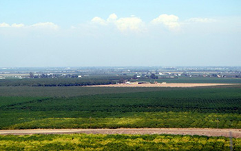
Researchers use satellite imaging to map groundwater use in California's Central ValleyЃЈЭМЃЉ
satellite imaging map groundwater California Central Valley
2020/10/16
Researchers at the University of California, San Diego report a new way to improve groundwater monitoring by using a remote sensing technology, known as InSAR (interferometric synthetic aper...
USING REMOTE SENSING DATA TO MODEL GROUNDWATER RECHARGE POTENTIAL IN KANYE REGION,BOTSWANA
Remote Sensing Water Resources Groundwater Recharge Arid Areas Kanye Region Limpopo Catchment
2015/12/28
This study focuses on the groundwater recharge potential in the upper Limpopo catchment starting from Kanye region in South Botswana. Existing high resolution remote sensing data were used to estimate...
GROUNDWATER LEVEL MONITORING MODEL USING MULTI-TEMPORAL IMAGES IN ARID REGION OF NORTHWEST CHINA
Hydrology Ecological Environment Multi-temporal Images Model Monitoring
2015/12/28
For the frangible ecological environment, it is very important to reasonably develop and utilize groundwater resources in Northwest China. Shallow groundwater level is an essential factor related to t...
MONITORING EVAPOTRANSPIRATION FOR TERRESTRIAL GROUNDWATER DEPENDANT ECOSYSTEMS USING SATELLITE-BASED ENERGY BALANCE MODEL
Remote sensing evapotranspiration surface energy balance Landsat groundwater ecosystems
2015/12/28
Understanding and mitigating against the impact of land use change and groundwater extraction on groundwater dependant ecosystems (GDE) requires information on the distribution and environmental water...
MONITORING OF HASHTGERD LAND SUBSIDENCE INDUCED BY OVEREXPLOITATION OF GROUNDWATER USING SAR INTERFEROMETRY
Interferometry Subsidence Aquifer Remote Sensing Geology Change Detection SAR Acquisition
2015/12/28
It was recognized that a large area in Hashtgerd plain, in the vicinity of Tehran, is subject to the land subsidence. GPS continuous measurements and precise leveling surveys carried out by National C...
Study of Morphotectonic and Hydrogeology for Groundwater Prospecting Using Remote Sensing and GIS in the North West Himalaya, District Sirmour, Himachal Pradesh, India
Satellite Imageries Neo-Tectonics GPS Hydrogeology Morphometric Analysis
2015/12/11
The study of aerial photographs, satellite images topographic maps supported by ground truth survey reveals that the study area has a network of interlinked subsurface fractures. The features of neo-t...
GROUNDWATER POTENTIAL ASSESSMENT USING GEOGRAPHIC INFORMATION SYSTEMS AND AHP METHOD (CASE STUDY: BAFT CITY, KERMAN, IRAN)
Underground Water AHP GIS Remote Sensing
2016/1/18
The purpose of the present study is to use Geographical Information Systems (GISs) for determining the best areas having ground water potential in Baft city. To achieve this objective, parameters such...
GIS BASED MODELING OF GEO-CHEMICAL QUALITY OF GROUNDWATER IN CHANDIGARH
GIS Geochemical parameters Groundwater
2015/8/28
As surface water is inadequate to meet the increasing human demand, groundwater sources are largely being resorted
to. Groundwater, many a times, is not adequate and safe for direct human consumption...
Geographical Information System (GIS) Based Groundwater Quality Mapping in the Western Doon Valley, Dehradun, Uttaranchal State
GIS Groundwater Quality Mapping Western Doon Valley
2015/8/28
Groundwater is the major source of drinking water in both urban and rural India, besides,
it is an important source of water for the agricultural and the industrial sectors. In the
Western Doon Vall...
Morphometric Analysis for Evaluating Groundwater Potential Zones, In Kusangai Jor Watershed Area, Dist., Bolangir, Orissa
Watershed GIS dendritic drainage
2015/8/28
The ЁЎmorphometric analysisЁЏ study coupled with remote sensing and GIS techniques evaluate different valuable parameters
for the watershed development plan of severely drought prone Kusangai Jor water...
INTEGRATED GROUNDWATER RESOURCE DEVELOPMENT IN HARD ROCK AREA AND ITS MANAGEMENT - A CASE STUDY
Remote Sensing GIS Over burden thickness
2015/8/28
Increasing population growth worldwide is putting increasing pressure on water resources. In arid and semi area pressure goes to
groundwater. Keeping in view havoc capability of remote sensing and GI...
Preliminary location of the groundwater wells using gis techniques: a case study of the hrh tasneem bint ghazi for technology research station
Color aerial photographs Tectonic Lines Groundwater Wells and ArcGIS
2015/8/21
The tectonic lines analysis is one of the prime concerns for the groundwater wells hydrologist during the reconnaissance and
feasibility stages in engineering site selection. Obtaining reliable data ...
1D resistivity sounding geophysical survey by using Schlumberger electrode configuration method for groundwater explorations in catchment area of Anjani and Jhiri river, Northern Maharashtra (India)
Geophysical survey 1D resistivity sounding VES cross section groundwater explorations Anjani and Jhiri River Maharashtra India
2015/8/14
The present paper focuses on groundwater exploration using scientific methods. The area decide for the study, Anjani and Jhiri river basin, which comes under hard rock terrain from Maharashtra provinc...
Groundwater Quality Mapping Based on the Geographical Information System (GIS) of Jammu District, Jammu and Kashmir India
Groundwater quality GIS Integration analysis Jammu district J&K India
2015/8/14
Geographical Information System (GIS) based groundwater quality mapping has been carried out with the help of hydrochemical data of Jammu district, Jammu and Kashmir State. Groundwater quality for dri...
3D MODELING OF GROUNDWATER BASED ON VOLUME VISUALIZATION TECHNOLOGY
Volume Visualization 3D Model Interpolate 3D Profile Groundwater Inverse Distance to a Power
2015/8/10
Water Resource is one of the most important nature resources, and it is the strategic resource for economic development. With the development of industry and agriculture, city population increasing, m...
жаЙњбаОПЩњНЬг§ХХааАё-Ьѕ
- е§дкМгди...
жаЙњбЇЪѕЦкПЏХХааАё-Ьѕ
- е§дкМгди...
ЪРНчДѓбЇПЦбаЛњЙЙХХааАё-Ьѕ
- е§дкМгди...
жаЙњДѓбЇХХааАё-Ьѕ
- е§дкМгди...
ШЫЁЁЮя-ЦЊ
- е§дкМгди...
ПЮЁЁМў-ЦЊ
- е§дкМгди...
ЪгЬ§зЪСЯ-ЦЊ
- е§дкМгди...
баеазЪСЯ -ЦЊ
- е§дкМгди...
жЊЪЖвЊЮХ-ЦЊ
- е§дкМгди...
ЙњМЪЖЏЬЌ-ЦЊ
- е§дкМгди...
ЛсвщжааФ-ЦЊ
- е§дкМгди...
бЇЪѕжИФЯ-ЦЊ
- е§дкМгди...
бЇЪѕеОЕу-ЦЊ
- е§дкМгди...