
搜索结果: 1-15 共查到“测绘科学技术 Changes”相关记录115条 . 查询时间(0.187 秒)
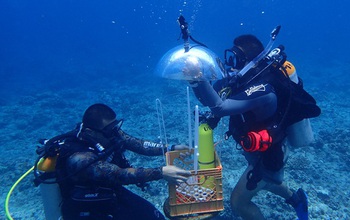
In Guam, researchers developed a method for mapping underwater areas that is transforming how oceanographers observe the seafloor. Data from global positioning satellites are the primary method for ma...
Portland State laser mapping project shows landscape changes in Antarctica
Portland State laser mapping project landscape changes Antarctica
2017/9/5
Portland State University researchers and the National Science Foundation (NSF) have publically released high-resolution maps of the McMurdo Dry Valleys, a globally unique Antarctic polar desert.The P...
LAND USE/LAND COVER CHANGES IN SEMI-ARID MOUNTAIN LANDSCAPE IN SOUTHERN INDIA: A GEOINFORMATICS BASED MARKOV CHAIN APPROACH
Land cover Markov Kallar NDVI Drought Geoinformatics
2017/7/12
Nowadays land use/ land cover in mountain landscape is in critical condition; it leads to high risky and uncertain environments. These areas are facing multiple stresses including degradation of land ...
DOCUMENTATION AND DETECTION OF COLOUR CHANGES OF BAS RELIEVES USING CLOSE RANGE PHOTOGRAMMETRY
Change Detection Colour Decay 3D Reconstruction Archaeology Digital Photogrammetry Classification Segmentation
2017/6/20
The digitization of complex buildings, findings or bas relieves can strongly facilitate the work of archaeologists, mainly for in depth analysis tasks. Notwithstanding, whether new visualization techn...
PHOTOGRAMMETRIC TECHNIQUES FOR ANALYSIS AND VISUALIZATION OF CHANGES IN 2D AND 3D DATA: PLASTIC SURGERY APPLICATION
Photogrammetry 3Dreconstruction shape changes visualization human body texturing data fusion
2017/6/19
Accurate measurements of 3D scenes and change detection of spatial distributed data are of great importance in different areas of research and application. For more accurate data analysis it is useful...
CHANGES IN SCATTERED GREENERY IN SELECTED AREA IN THE CZECH REPUBLIC FROM 1953 TO 2014
Land Cover Greenery History Distance Analysis
2016/12/1
The Land Cover of the Czech landscape could change several times. Reconstructing Land Cover and especially greenery in the past is important for today’s use of the landscape. Two periods were chosen t...
SPATIAL CHANGES AND POPULATION MOVEMENTS ON THE ALBANIAN COASTLINE
Change detection urban growth coastal erosion migration Albanian coastline CVA anthropology multidisciplinary research
2016/12/1
The last decade has seen a large increase in construction along the southern Albanian coastline, mainly in the rise of large tourist complexes comprising hotels, apartment houses, touristic villages, ...
APPLYING UAV AND PHOTOGRAMMETRY TO MONITOR THE MORPHOLOGICAL CHANGES ALONG THE BEACH IN PENGHU ISLANDS
UAV beach monitoring Digital Surface Model Tombolo
2016/12/1
Penghu islands, in the southern Taiwan Strait, is a remnant of a middle-late Miocene basaltic shield volcano. We present a procedure to use UAV (Unmanned Aerial Vehicles) to perform photogrammetry sur...
LAND USE AND LAND COVER CHANGES AND URBAN SPRAWL IN RIYADH,SAUDI ARABIA:AN ANALYSIS USING MULTI-TEMPORAL LANDSAT DATA AND SHANNON'S ENTROPY INDEX
Land Use Land Cover Change Shannon’s Entropy Riyadh
2016/12/1
The city of Riyadh, Saudi Arabia has experienced rapid population growth and urban expansion over the past several decades. Due to such growth, the capital city faces many short and long-term social a...
PREDICTION OF CHANGES IN VEGETATION DISTRIBUTION UNDER CLIMATE CHANGE SCENARIOS USING MODIS DATASET
MODIS Beech Prediction modelling Climate change
2016/12/1
The distribution of vegetation is expected to change under the influence of climate change. This study utilizes vegetation maps derived from Terra/MODIS data to generate a model of current climate con...
VEGETATION CHANGES AND THE RELATIONSHIP WITH CLIMATE VARIABILITY IN THE UPPER AND MIDDLE REACHES OF THE NENJIANG RIVER BASIN,CHINA
Vegetation Dynamics NDVI Climate Variability Correlation Analysis Rescaled Range Analysis SPOT VEGETATION the Upper and Middle Reaches of the Nenjiang River
2016/12/1
To detect changes in vegetation is desirable for modeling and predicting interactions between land surface and atmosphere. Multitemporal series of SPOT VEGETATION NDVI dataset and meteorological data ...
ESTIMATING CARBON STOCK CHANGES OF MANGROVE FORESTS USING SATELLITE IMAGERY AND AIRBORNE LiDAR DATA IN THE SOUTH SUMATRA STATE,INDONESIA
LiDAR Satellite imagery Biomass Carbon stock change Mangrove forest
2016/11/30
The purposes of this study were 1) to estimate the biomass in the mangrove forests using satellite imagery and airborne LiDAR data, and 2) to estimate the amount of carbon stock changes using biomass ...
REMOTE SENSING APPLICATION OF THE GEOPHYSICAL CHANGES IN THE COASTLINES AND RIVERS OF ZAMBALES,PHILIPPINES
Remote Sensing Accretion Erosion Geophysical changes Lahar
2016/11/30
Geophysical changes in river outlet, river upstream and coastlines near the rivers of Bucao and Santo Tomas in Zambales, Philippines were analyzed using the Google Earth’s historical satellite imageri...
GLOBAL CHANGES IN THE SEA ICE COVER AND ASSOCIATED SURFACE TEMPERATURE CHANGES
Global sea ice surface temperature trends climate change remote sensing
2016/11/30
The trends in the sea ice cover in the two hemispheres have been observed to be asymmetric with the rate of change in the Arctic being negative at −3.8 % per decade while that of the Antar...
MASS BALANCE CHANGES AND ICE DYNAMICS OF GREENLAND AND ANTARCTIC ICE SHEETS FROM LASER ALTIMETRY
Laser Atimetry Surface Elevation Changes Greenland Antarctica Ice Sheet Mass Balance Sea-Level Rise
2016/11/30
During the past few decades the Greenland and Antarctic ice sheets have lost ice at accelerating rates, caused by increasing surface temperature. The melting of the two big ice sheets has a big impact...