
�������: 1-15 ���鵽����ѧ Vertical����ؼ�¼108�� . ��ѯʱ��(0.106 ��)
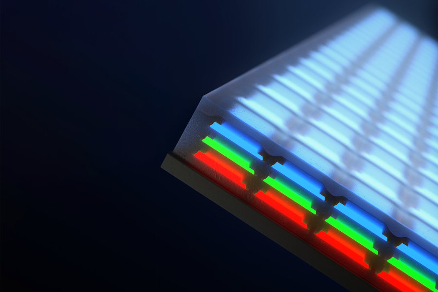
Engineers invent vertical, full-color microscopic LEDs��ͼ��
��ֱȫ�� ��LED �ѵ���������� ������Ļ
2023/6/6
Take apart your laptop screen, and at its heart you��ll find a plate patterned with pixels of red, green, and blue LEDs, arranged end to end like a meticulous Lite Brite display. When electrically powe...
Condensation heat transfer of steam on vertical dropwise and filmwise coexisting surfaces with a thick organic film promoting dropwise
���� ��״ Ĥ״ DFC ��������
2023/3/1
This article describes an experimental investigation of the condensation heat transfer of steam on dropwise and filmwise coexisting (DFC) surfaces, on which dropwise and filmwise exist simultaneously ...
ON VERTICAL DISTRIBUTION OF MAJOR AEROSOL TYPES OVER DIFFERENT PARTS OF ASIA
CALIOP dust polluted dust smoke Asia
2019/2/28
Asia, being the largest continent, both in its size and population is affected by different types of atmospheric aerosols. Also, owing to different local emissions/sources along with the long range tr...
ESTIMATION OF PM2.5 VERTICAL DISTRIBUTION USING CUSTOMIZED UAV AND MOBILE SENSORS IN BRGY. UP CAMPUS, DILIMAN, QUEZON CITY
Unmanned Aerial Vehicle Air Quality Quezon City Monitoring Particulate matter (PM) Concentration PM2.5 Meteorological Parameters
2018/11/8
As the unmanned aerial vehicle (UAV) technology has gained popularity over the years, it has been introduced for air quality monitoring. This study demonstrates the feasibility of customized UAV with ...
A POINT CLOUD CLASSIFICATION APPROACH BASED ON VERTICAL STRUCTURES OF GROUND OBJECTS
airborne LiDAR vertical structural characteristics urban point cloud ground objects classification
2018/5/17
This paper proposes a novel method for point cloud classification using vertical structural characteristics of ground objects. Since urbanization develops rapidly nowadays, urban ground objects also c...
VERTICAL ACCURACY EVALUATION OF ASTER GDEM2 OVER A MOUNTAINOUS AREA BASED ON UAV PHOTOGRAMMETRY
Global Digital Elevation Model ASTER GDEM2 UAV Photogrammetry Accuracy Evaluation Geodesy
2018/6/4
Global digital elevation models (GDEM) provide elementary information on heights of the Earth��s surface and objects on the ground. GDEMs have become an important data source for a range of application...
USE OF VERTICAL AERIAL IMAGES FOR SEMI-OBLIQUE MAPPING
Aerial photogrammetry Oblique camera Modelling Mapping
2017/7/13
The paper proposes a methodology for the use of the oblique sections of images from large-format photogrammetric cameras, by exploiting the effect of the central perspective geometry in the lateral pa...
VERTICAL ACCURACY COMPARISON OF DIGITAL ELEVATION MODEL FROM LIDAR AND MULTITEMPORAL SATELLITE IMAGERY
Vertical Accuracy LiDAR DEM Multitemporal Stereo Satellite Imagery DEM
2017/7/13
Digital elevation model serves to illustrate the appearance of the earth's surface. DEM can be produced from a wide variety of data sources including from radar data, LiDAR data, and stereo satellite ...
VERTICAL ACCURACY ASSESSMENT OF ZY-3 DIGITAL SURFACE MODEL USING ICESAT/GLAS LASER ALTIMETER DATA
Accuracy assessment ZY-3 stereo images DSM ICESat/GLAS
2017/7/12
The Ziyuan-3 (ZY-3) satellite, as the first civilian high resolution surveying and mapping satellite in China, has a very important role in national 1 : 50,000 stereo mapping project. High...
AUTOMATIC GENERATION OF BUILDING MAPPING USING DIGITAL,VERTICAL AND AERIAL HIGH RESOLUTION PHOTOGRAPHS AND LIDAR POINT CLOUDS
Cartography Automatic Extraction Photogrammetry Aerial Photographs Image Segmentation
2016/11/23
The objective of this research is automatic generation of buildings in the interest areas. This research was developed by using high resolution vertical aerial photographs and the LIDAR point cloud th...
THE POTENTIAL OF LOW-COST RPAS FOR MULTI-VIEW RECONSTRUCTION OF SUB-VERTICAL ROCK FACES
UAV Close Range Photogrammetry Structure from Motion Action Camera Calibration Accuracy Coded Targets Natural Features
2016/11/11
The current work investigates the potential of two low-cost off-the-shelf quadcopters for multi-view reconstruction of sub-vertical rock faces. The two platforms used are a DJI Phantom 1 equipped with...
TREE STEM RECONSTRUCTION USING VERTICAL FISHEYE IMAGES: A PRELIMINARY STUDY
Dense Reconstruction Fisheye Image Rectification Photogrammetry
2016/11/11
A preliminary study was conducted to assess a tree stem reconstruction technique with panoramic images taken with fisheye lenses. The concept is similar to the Structure from Motion (SfM) technique, b...
VERTICAL ACCURACY ASSESSMENT OF 30-M RESOLUTION ALOS, ASTER, AND SRTM GLOBAL DEMS OVER NORTHEASTERN MINDANAO, PHILIPPINES
AW3D30 ASTER GDEM2 SRTM-30m Digital Elevation Model Accuracy Assessment Philippines
2016/11/8
The ALOS World 3D �C 30 m (AW3D30), ASTER Global DEM Version 2 (GDEM2), and SRTM-30 m are Digital Elevation Models (DEMs) that have been made available to the general public free of charge....
DUBAI 3D TEXTUERD MESH USING HIGH QUALITY RESOLUTION VERTICAL/OBLIQUE AERIAL IMAGERY
Oblique Texturing 3D Dense Matching Mesh Dubai Municipality DSM
2016/7/27
Providing high quality 3D data with reasonable quality and cost were always essential, affording the core data and foundation for developing an information-based decision-making tool of urban environm...
A ROLE FOR AIRBORNE LASER SCANNING INTENSITY DATA IN VERTICAL STRATIFICATION OF MULTILAYERED ECOSYSTEMS
airborne laser scanning intensity LiDAR shrubland wildland fi res
2016/2/29
Airborne laser scanning (ALS) based height and intensity information was exploited for the vertical stratification of vegetation layers in
a multilayered Mediterranean ecosystem. A new methodol...
�й��о����������а�-��
- ���ڼ���...
�й�ѧ���ڿ����а�-��
- ���ڼ���...
�����ѧ���л������а�-��
- ���ڼ���...
�й���ѧ���а�-��
- ���ڼ���...
�ˡ���-ƪ
- ���ڼ���...
�Ρ���-ƪ
- ���ڼ���...
��������-ƪ
- ���ڼ���...
�������� -ƪ
- ���ڼ���...
֪ʶҪ��-ƪ
- ���ڼ���...
���ʶ�̬-ƪ
- ���ڼ���...
��������-ƪ
- ���ڼ���...
ѧ��ָ��-ƪ
- ���ڼ���...
ѧ��վ��-ƪ
- ���ڼ���...
