搜索结果: 1-15 共查到“地理学 GIS”相关记录86条 . 查询时间(0.109 秒)

第一届中国农业大学GIS制图大赛决赛暨颁奖仪式成功举行(图)
中国农业大学 GIS制图 决赛 颁奖仪式
2021/7/14
2021年6月22日下午,“GIS地图谱写百年征程 初心不忘放飞青春理想”第一届中国农业大学GIS制图大赛决赛暨颁奖仪式在东区信电237会议室成功举行。本次大赛由中国农业大学地理信息协会主办,面向全校同学参赛,属于校团委“五月的花海”系列活动。大赛旨在加强同学们关于GIS制图技术的理解和实践能力,并为广大青年学子提供用地图祖国河山、用地图解读百年党史的新视角。
地理信息系统(GIS)与中国历史研究
历史地理信息系统 中国史 研究与应用
2022/4/8
历史地理信息系统建设是信息化时代学术发展的要求,也是历史研究向纵深方向拓展的体现。作为历史信息存储、显示、管理、分析系统,近年来,国内相关数据平台越建越多,GIS对中国史学研究的贡献也初见成效,在历史气候、河流地貌、市镇经济、乡村聚落、水利社会、环境变迁、古代城市、古地图以及HGIS研究方法等9大领域都有突出的表现。GIS进入中国史学研究领域不仅带来研究方法的变革,同时也使历史研究理念更新,促成历...
虚实融合技术是视频增强三维虚拟地理场景的关键环节之一,对提高真实沉浸式视觉体验具有重要作用。现有基于视频投影的虚实融合方法,在三维场景动态更新时,通常需要对用户视角下新场景内所有渲染对象进行遍历,来筛选出摄像头范围内需融合的对象,导致融合过程耗时长、效率不高。本文提出一种顾及拓扑关系的多路视频与三维GIS场景融合的对象快速确定方法。首先对三维场景视锥体内视频对象集渲染对象动态建立拓扑网络模型;然后...
中国矿业大学(北京)2019年硕士生自命题GIS基础考试大纲。

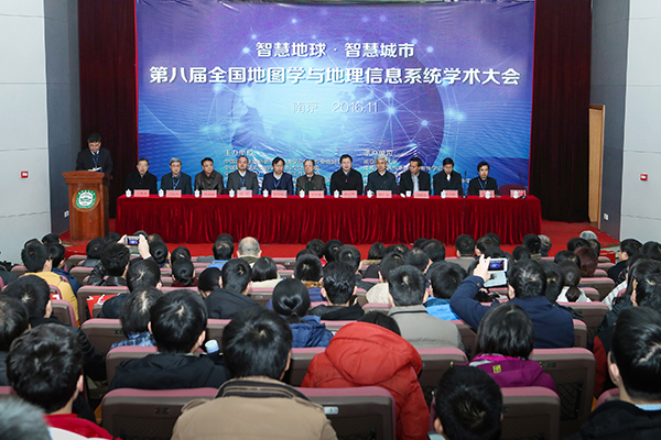
2016年11月25至28日,第八届全国地图学与GIS学术大会在南京师范大学举行。本届大会由中国测绘地理信息学会地图学与GIS专业委员会、中国地理学会地图学与GIS专委会、中国地理信息产业协会地图工作委员会、中国地质学会地质制图与地理信息专委会、中国自然资源学会资源制图专委会五家联合主办,由南京师范大学及省遥感与GIS学会、省测绘地理信息学会、省地理信息资源开发与利用协同创新中心、虚拟地理环境教育...
南京师范大学地理科学学院地图学(实验)英文课件Experiment2 Map projection function in GIS software
南京师范大学地理科学学院 地图学 实验 英文 课件 Experiment2 Map projection function in GIS software
2015/7/15
南京师范大学地理科学学院地图学(实验)英文课件Experiment2 Map projection function in GIS software。
DIDACTIC AND METHODOLOGICAL CHALLENGES IN NEW MEDIA BASED TEACHING AND LEARNING FOR GIS
Didactical Design Learning Theories
2015/3/12
New Media teaching and learning is on everyone’s lips at the moment. It must be analyzed whether e-learning and multimedia with
its possibilities can make a lasting contribution to the university te...

江苏省地理学会、江苏省遥感与GIS学会2014年会圆满落幕(图)
江苏省地理学会 江苏省遥感与GIS学会 2014 年会
2014/12/12
为进一步推动江苏省地理学的交流与发展,江苏省地理学会、江苏省遥感与地理信息系统学2014年度学术交流大会于2014年12月4-6日在南通召开。本次会议以“陆海统筹发展与地理学创新”为主题。会议由江苏省地理学会、江苏省遥感与地理信息系统学会主办,南通大学地理科学院承办,中国科学院南京地理与湖泊研究所、南京大学、南京师范大学协办。来自南京大学、南京师范大学、南通大学、中国科学院南京地理与湖泊研究所、河...
GIS approach in assessing the status of neritic water quality and petroleum hydrocarbons in Bay of Bengal (From Chennai to Nagapattinam, Tamilnadu), India
GIS coastal water quality petroleum hydrocarbons wind direction wetland
2014/11/26
Neritic coastal water samples, collected onboard in Ocean Research Vessel (Sagar Purvi,
NIOT) at a depth of 15m from the shore in August, 2010 at 15 coastal stations (opposite to
the river mouths,...
Monitoring of bank line erosion of River Ganga, Malda District, and West Bengal: Using RS and GIS compiled with statistical techniques
River Migration banks failure paradigm shift mitigation of disasters
2014/11/26
The creation of regional imbalance, inequalities and differentiation in India, starts with the
physiographic element and ends with economic, and socio-cultural parameters of the
inhabitants/popula...
Geo-Hydrological study of Gandheshwari Sub-watershed using Remote Sensing and GIS Techniques
Geo-hydrology hydro-geomorphology remote sensing GIS and GPS
2014/11/26
The present study was conducted on Gandheshwari sub-watershed situated in Bankura
district of West Bengal. The remote sensing and GIS techniques have been proved to be very
efficient in...
Evaluation of hydrogeomorphological landforms and lineaments using GIS and Remote Sensing techniques in Bargur – Mathur subwatersheds, Ponnaiyar River basin, India
Hydrogeomorphology Lineament Remote Sensing GIS Bargur – Mathur
2014/11/26
The Landsat ETM satellite data is used to demarcate hydrogeomorphological landforms and
lineaments to evaluate groundwater potential of the study area. The Bargur - Mathur
subwatersheds of Ponnaiy...
GIS based lineament Delineation using geophysical resistivity data, Karur district, Tamil Nadu, India
Lineament Geophysical resistivity DEM GIS
2014/11/26
The paper shows that geophysical resistivity values Digital Elevation Model (DEM) for
different depths, can indicate the location of depth persistence lineaments. The depth
persistence lineaments ...
Online web GIS- based services for spatial data and sharing of leptospirosis epidemiology information; Development of pilot project in Mahasarakham province Thailand
Web GIS-based service spatial data sharing leptospirosis epidemiology
2014/11/26
Leptospirosis epidemiology Information sharing is important for the shared preparation,
response, and recovery stages of sickness control. Leptospirosis epidemiology phenomena
are powerfully assoc...
GIS based mapping and environmental impact of Wetlands changes in a Riverine district of Bangladesh
Bangladesh Wetlands Changes Management Environmen
2014/11/26
This research is concerned with the GIS based mapping and change of areal extent of
wetlands within two different periods and to identify the causes of change and impact
assessment of wetland chan...


