搜索结果: 1-15 共查到“理学 topographic”相关记录81条 . 查询时间(0.116 秒)

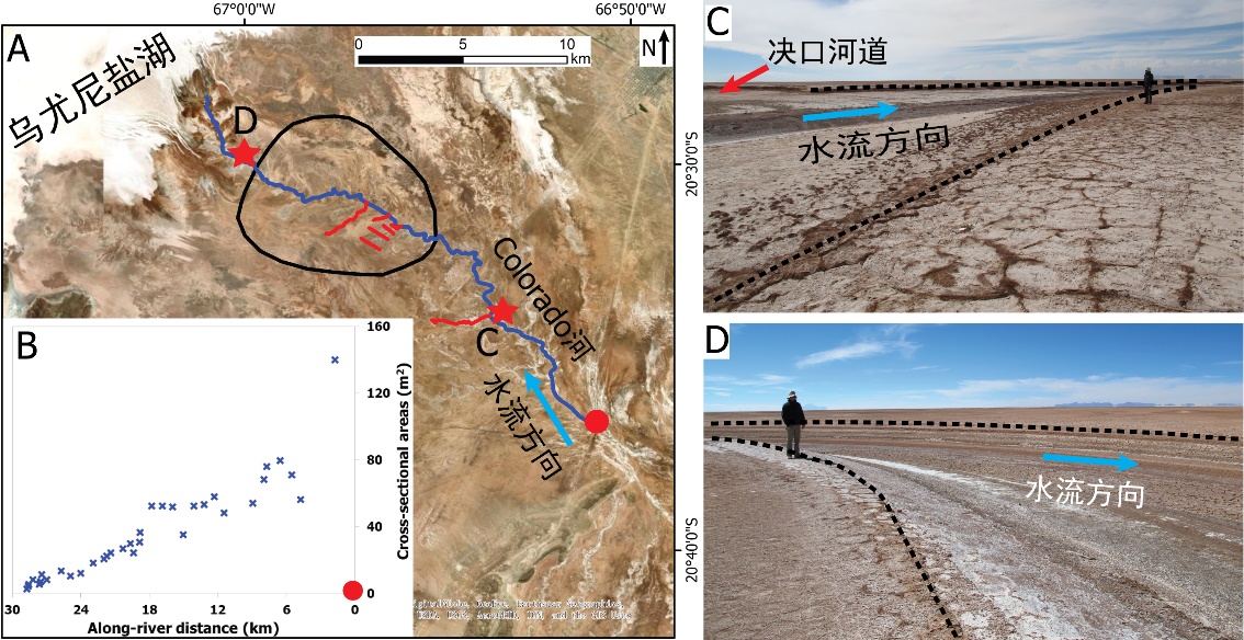
中国地质大学科学技术发展院李嘉光* 等,资源学院. Journal of Hydrology(2020), Digital Elevation Models for topographic characterisation and flood flow modelling along low-gradient, terminal dryland rivers: A comparison of spaceborne datasets for the Río Colorado, Bolivia(图)
精确表征;极低;缓河流;末端;地形;模拟河道;洪水;漫溢
2021/10/15
近日,国际知名期刊Journal of Hydrology在线刊发了中国地质大学资源学院李嘉光副教授团队在陆相湖盆边缘河流末端沉积体系研究的最新成果——Digital Elevation Models for topographic characterisation and flood flow modelling along low-gradient, terminal dryland rive...
STUDY ON SITE CONDITIONS BASED ON TOPOGRAPHIC SLOPE
DEM, Topographic Slope, Vs30, Site Conditions
2018/5/15
The travel-time averaged shear-wave velocity to a depth of 30m (Vs30) below the Earth’s surface is widely used to classify sites in many building codes. Vs30 is also used to estimate site classificati...
TOPOGRAPHIC FEATURES OF MALYY NARYN RIVER WATERSHED BASED ON DIFFERENT DATA
ZY3 DSM SRTM DEM ASTER GDEM Topographic Features Slop HI River Network Density River Network Discrepancy
2018/5/14
This paper researched the influence on the topographical characteristics of watersheds by setting different catchment area thresholds based on different data sets, namely ZY3 DSM, SRTM DEM and ASTER G...
南京师范大学地理科学学院地图学(实验)英文课件Experiment1 Subdivision and Numbering of Topographic map
南京师范大学地理科学学院 地图学 实验 英文 课件 Experiment1 Subdivision and Numbering of Topographic map
2015/7/15
南京师范大学地理科学学院地图学(实验)英文课件Experiment1 Subdivision and Numbering of Topographic map。
Barotropic tides generate energetic internal tides, smaller-scale
waves, and turbulence as they flow through Luzon Strait, between Taiwan and
the Philippines. Three-dimensional numerical simulatio...
Aspects of Data Modeling of Fused Surfaces with Planimetric Data in a Topographic Geodatabase
Raster TIN Accuracy
2015/7/6
As a result of building a topological surfaced geodatabase for the test area, the paper discuses the investigation of modeling 3D
surface data, and its fusion with other planinmetric modeled data, an...
Algorithmic Development of an Optimal Path Computation Model Based on Topographic Map Features
GIS Mapping Modelling,
2015/7/6
Path finding problems have attracted widespread research interests with different GIS-T applications such as Logistics applications,
Infrastructure Planning and Travel Demand analysis. Previous resea...
An inventory of topographic surface changes: the value of multi-temporal elevation data for change analysis and monitoring
DEM/DTM Geomorphology Change Detection SAR, Multitemporal Monitoring Accuracy Error
2014/7/23
Landscape change resulting from human activities continues to be a primary topic in geographic research. Many studies have focused upon human-induced changes in two dimensions, namely in land cover. H...
The 2010Mw8.8 Maule, Chile earthquake: Nucleation and rupture propagation controlled by a subducted topographic high
2010Mw8.8 Maule Chile earthquake Nucleation rupture propagation controlled a subducted topographic high
2014/4/9
Knowledge of seismic properties in an earthquake rupture zone is essential for understanding the factors controlling rupture dynamics. We use data from aftershocks following the Maule earthquake to de...
Numerical Modelling of the Topographic Wetness Index: An Analysis at Different Scales
Resolution DEM Grid Size Wetness Index
2013/3/7
A variety of landscape properties have been modeled successfully using topographic indices such as topographic wetness index (TWI), defined as ln(a/tanβ), where a is the specific upslope area and β is...
Topographic effects on solar radiation distribution in mountainous watersheds and their influence on reference evapotranspiration estimates at watershed scale
solar radiation distribution mountainous watersheds
2010/12/22
Distributed energy and water balance models require time-series surfaces of the climatological variables involved in hydrological processes. Among them, solar radiation constitutes a key variable to ...
Topographic and electronic contrast of the graphene moiré on Ir(111) probed by scanning tunneling microscopy and non-contact atomic force microscopy
Topographi electronic contrast tunneling microscopy non-contact atomic force microscopy
2010/11/23
Epitaxial graphene grown on single crystal transition metal surfaces typically exhibits a moiré
pattern due to the lattice mismatch between graphene and the underlying metal surface. We use si-multan...
Reading the bed morphology of a mountain stream:a geomorphometric study on high-resolution topographic data
bed morphology mountain stream geomorphometric study high-resolution topographic data
2010/3/5
High-resolution topographic data expand the potential of quantitative analysis of the earth surface, improving the interpretation of geomorphic processes. In particular, the morphologies of the channe...
Topographic instability of flow in a rotating fluid
Topographic instability of flow rotating fluid
2009/11/9
Here are presented the results of experimental and theoretical studies on a stability of zonal geostrophic flows in the rotating layer of the shallow water. In the experiments, a special apparatus by ...
Distribution of bog and heath in a Newfoundland blanket bog complex:topographic limits on the hydrological processes governing blanket bog development
derived from digital elevation models bog development multinomial logit
2009/5/26
This research quantified the role of topography and hydrological processes within and, hence, the development of, blanket bogs. Topographic characteristics were derived from digital elevation models (...


