搜索结果: 1-15 共查到“理学 Survey”相关记录314条 . 查询时间(0.14 秒)

《Lithofacies Paleogeography and Geological Survey of Shale Gas》专著在Springer出版(图)
石油天然气 中国地质调查局 页岩气
2023/7/18
2022年,在中国地质调查局成都地质调查中心成立60周年之际,为进一步传承与发扬中心岩相古地理传统优势学科,凸显岩相古地理研究理论和编图方法创新性成果,突出其在支撑新一轮找矿突破战略行动中基础性、指导性、方法性等共识性认识,提升中国地质调查局成都地调中心及岩相古地理优势学科在国内外的影响力,《Lithofacies Paleogeography and Geological Survey of S...
Academy of Mathematics and Systems Science, CAS Colloquia & Seminars:A Survey of Stability of Peaked Solitons II: Multicomponent Case
峰值孤子 稳定性 多组分案例
2023/4/27
Academy of Mathematics and Systems Science, CAS Colloquia & Seminars:A Survey of Stability of Peaked Solitons I: Scalar Case
峰值孤子 稳定性 标量案例
2023/4/27

Sky survey reveals newborn jets in distant galaxies(图)
Sky survey newborn jets distant galaxies
2020/12/11
Astronomers using data from the ongoing VLA Sky Survey have found distant galaxies with supermassive black holes at their cores that have launched powerful, radio-emitting jets of material w...
山东大学生命科学学院生物化学课件 A Survey of Metabolism。

Survey completeness of a global citizen-science database of bird occurrence(图)
Survey completeness global citizen-science database bird occurrence
2019/10/28
There are many shortfalls in knowledge of the world's biodiversity, and one of the most basic is the lack of knowledge about where species occur geographically. This deficiency has broad ramifications...
DEVELOPMENT AND APPLICATION OF THE KEY TECHNOLOGIES FOR THE QUALITY CONTROL AND INSPECTION OF NATIONAL GEOGRAPHICAL CONDITIONS SURVEY PRODUCTS
Geographical Condition Survey Quality Control Quality Inspection and Testing Total Quality Control Target Survey Products
2018/5/17
The First National Geographical Condition Survey is a predecessor task to dynamically master basic situations of the nature, ecology and human activities on the earth’s surface and it is the brand-new...
“TORINO 1911” PROJECT: A CONTRIBUTION OF A SLAM-BASED SURVEY TO EXTENSIVE 3D HERITAGE MODELING
SLAM photogrammetry LiDAR Zeb Revo RT Mobile Mapping Systems landscape Cultural Heritage
2018/6/4
In the framework of the digital documentation of complex environments the advanced Geomatics researches offers integrated solution and multi-sensor strategies for the 3D accurate reconstruction of str...
FROM A POINT CLOUD SURVEY TO A MASS 3D MODELLING: RENAISSANCE HBIM IN POGGIO A CAIANO
Point clouds Digital accuracy Parametric mass modelling HBIM Renaissance architecture Scan to BIM
2018/6/4
This paper introduces some studies developed regarding the Medicea Villa at Poggio a Caiano, in Italy. The monumental building was built by Lorenzo de’ Medici and his heirs following the design of the...

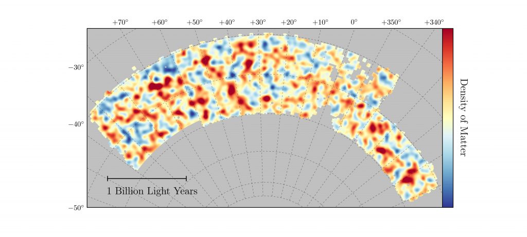
Dark Energy Survey reveals most accurate measurement of dark matter structure in the universe(图)
Dark Energy Survey most accurate measurement dark matter structure the universe
2017/9/4
Imagine planting a single seed and, with great precision, being able to predict the exact height of the tree that grows from it. Now imagine traveling to the future and snapping photographic proof tha...
SURVEY, HBIM AND CONSERVATION PLAN OF A MONUMENTAL BUILDING DAMAGED BY EARTHQUAKE
Survey structural geometry earthquake HBIM conservation project
2017/6/20
Surveying a monumental building damaged by the earthquake means to analyse its geometries, the structural elements, the connection still exist between the different parts, in order to define its state...
METRIC SURVEY AND BIM TECHNOLOGIES TO RECORD DECAY CONDITIONS
Metric survey H-BIM 3D decays Data enrichment Integrated workflow TLS
2017/6/20
The paper proposes a method able to describe, classify and organize information assets concerned with Architectural Heritage, through the use of integrated survey procedures, mainly based on Terrestri...
Pan-STARRS Releases Largest Digital Sky Survey to the World
Pan-STARRS Releases Largest Digital Sky Survey the World
2016/12/27
The Pan-STARRS project at the University of Hawaii Institute for Astronomy is publicly releasing the world's largest digital sky survey today, via the Space Telescope Science Institute (STScI) in Balt...
INFLUENCE OF RIVER BED ELEVATION SURVEY CONFIGURATIONS AND INTERPOLATION METHODS ON THE ACCURACY OF LIDAR DTM-BASED RIVER FLOW SIMULATIONS
LiDAR Digital Terrain Model River Bed Survey Configuration Interpolation Integration Flow Simulation
2016/10/14
In this paper, we investigated how survey configuration and the type of interpolation method can affect the accuracy of river flow simulations that utilize LIDAR DTM integrated with interpolated river...
Undernutrition screening survey in 564,063 patients: patients with a positive undernutrition screening score stay in hospital 1.4 d longer
LOS malnutrition undernutrition hospital screening
2018/11/28
Background: Undernutrition is a common complication of disease and a major determinant of hospital stay outcome. Dutch hospitals are required to screen for undernutrition on the first day of admission...


