
ЫбЫїНсЙћ: 1-15 ЙВВщЕНЁАРэбЇ DigitalЁБЯрЙиМЧТМ103Ьѕ . ВщбЏЪБМф(0.25 Уы)
Large animal veterinarians ЈC who trek to muddy barns and fields each day to work with their patients ЈC face challenges when it comes to keeping records. Minerva Panda has an idea for a software applic...
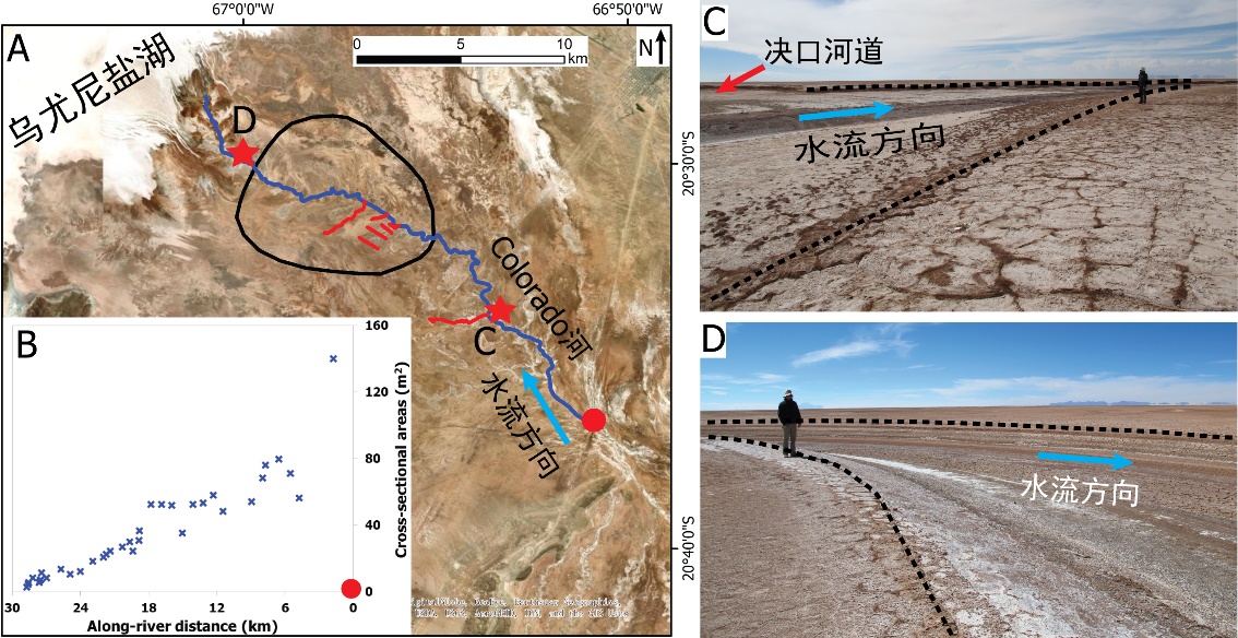
жаЙњЕижЪДѓбЇПЦбЇММЪѕЗЂеЙдКРюМЮЙт* ЕШЃЌзЪдДбЇдК. Journal of HydrologyЃЈ2020ЃЉ, Digital Elevation Models for topographic characterisation and flood flow modelling along low-gradient, terminal dryland rivers: A comparison of spaceborne datasets for the RЈЊo Colorado, BoliviaЃЈЭМЃЉ
ОЋШЗБэеїЃЛМЋЕЭЃЛЛККгСїЃЛФЉЖЫЃЛЕиаЮЃЛФЃФтКгЕРЃЛКщЫЎЃЛТўвч
2021/10/15
НќШеЃЌЙњМЪжЊУћЦкПЏJournal of HydrologyдкЯпПЏЗЂСЫжаЙњЕижЪДѓбЇзЪдДбЇдКРюМЮЙтИБНЬЪкЭХЖгдкТНЯрКўХшБпдЕКгСїФЉЖЫГСЛ§ЬхЯЕбаОПЕФзюаТГЩЙћЁЊЁЊDigital Elevation Models for topographic characterisation and flood flow modelling along low-gradient, terminal dryland rive...
A R-SHINY BASED PHENOLOGY ANALYSIS SYSTEM AND CASE STUDY USING DIGITAL CAMERA DATASET
Vegetation Phenology R-Shiny Digital Camera ROI Double Logistic Methods
2018/5/17
Accurate extracting of the vegetation phenology information play an important role in exploring the effects of climate changes on vegetation. Repeated photos from digital camera is a useful and huge d...
3D RECONSTRUCTION-REVERSE ENGINEERING ЈC DIGITAL FABRICATION OF THE EGYPTIAN PALERMO STONE USING BY SMARTPHONE AND LIGHT STRUCTURED SCANNER
Cultural Heritage Structured Light Scanning Smartphone 3D modeling 3D sculpting Digital Fabrication
2018/6/4
This paper presents a pipeline that has been developed to acquire a shape with particular features both under the geometric and radiometric aspects. In fact, the challenge was to build a 3D model of t...
DIGITAL TECHNOLOGY IN PRESERVATION OF BUDDIST MONASTERY TREASURES
Education Digital Documentation International Heritage Preservation Earthquake Risk Assessment Buddhist Monastery Preservation
2017/8/31
Treasure Caretaker Training (Digital Monastery Project), teaches Buddhist monks, nuns and community cultural caretakers to protect and preserve their own monastery sacred art treasures. Participants l...
2017Ъ§зжОМУЭГМЦЮяРэбЇбаЬжЛсЃЈStatistical Physics for the Digital Economy WorkshopЃЉ
2017 Ъ§зжОМУЭГМЦЮяРэбЇ баЬжЛс
2017/7/3
The last few years have seen the emergence of novel and entirely digital forms of economic exchange. Indeed, we have witnessed the emergence of sharing economy marketplaces where individuals can share...
New many-toothed clingfish discovered with help of digital scans
New many-toothed clingfish digital scans
2017/4/27
A set of curious researchers, state-of-the-art visual technology and a bit of good luck helped find a new fish whose tooth collection could put a shark to shame.Scientists at the University of Washing...
2017ФъЙњМЪвЦЖЏдЦАВШЋЃЌвўЫНКЭЪ§зжШЁжЄбаЬжЛсЃЈThe International Workshop on The Security, Privacy, and Digital Forensics of Mobile Cloud ЃЉ(SeMoCloud 2017)
2017Фъ ЙњМЪвЦЖЏдЦ АВШЋ вўЫН Ъ§зжШЁжЄ баЬжЛс
2017/3/27
To many people, smartphones and similar mobile devices have been an indispensable part of daily life and work. With personal financial and medical information and job related data being processed on t...
Pan-STARRS Releases Largest Digital Sky Survey to the World
Pan-STARRS Releases Largest Digital Sky Survey the World
2016/12/27
The Pan-STARRS project at the University of Hawaii Institute for Astronomy is publicly releasing the world's largest digital sky survey today, via the Space Telescope Science Institute (STScI) in Balt...
New ЁЎDigital LifeЁЏ Initiative at UMass Amherst Aims to Create 3D Models of All Living Creatures
Digital Life UMass Amherst Aims Create 3D Models All Living Creatures
2016/11/29
Scientists at the University of Massachusetts Amherst led by biologist Duncan Irschick who created the Beastcam Array, a rapid-capture, field portable tabletop system for making high-resolution, full-...
OPEN-SOURCE DIGITAL ELEVATION MODEL (DEMs) EVALUATION WITH GPS AND LiDAR DATA
Digital Elevation Model inundation mapping vertical accuracy LiDAR scale factor coastal inundation risk assessment
2016/10/14
Advanced Spaceborne Thermal Emission and Reflection Radiometer-Global Digital Elevation Model (ASTER GDEM), Shuttle Radar Topography Mission (SRTM), and Global Multi-resolution Terrain Elevation Data ...
SEMI-AUTOMATED APPROACH FOR MAPPING URBAN TREES FROM INTEGRATED AERIAL LiDAR POINT CLOUD AND DIGITAL IMAGERY DATASETS
Extraction Integrated Airborne LiDAR Multispectral Image Urban Trees
2016/10/14
Mapping of trees plays an important role in modern urban spatial data management, as many benefits and applications inherit from this detailed up-to-date data sources. Timely and accurate acquisition ...
Development of a new generation gravity map of Antarctica: ADGRAV Antarctic Digital Gravity Synthesis
Gravity Antartica
2015/10/8
The U.S. National Science Foundation (NSF) has agreed to support the development of a new generation gravity map of Antarctica (ADGRAV - Antarctic Digital Gravity Synthesis), funding the development o...
Digital elevation models for landslide evolution monitoring: application on two areas located in the Reno River Valley (Italy)
Digital Elevation Model landslide GPS digital photogrammetry laser scanning
2015/9/15
GPS, digital photogrammetry and laser scanning techniques have been applied and compared in the frame of the studies of two complex landslides located in the Emilia-Romagna Region (Northern Italy). Th...
Automated DEM extraction in digital aerial photogrammetry: precisions and validation for mass movement monitoring
digital photogrammetry automatic processing DEM precision monitoring
2015/9/10
Automated procedures for photogrammetric image processing and Digital Elevation Models (DEM) extraction
yield high precision terrain models in a short time, reducing manual editing; their accuracy is...
жаЙњбаОПЩњНЬг§ХХааАё-Ьѕ
- е§дкМгди...
жаЙњбЇЪѕЦкПЏХХааАё-Ьѕ
- е§дкМгди...
ЪРНчДѓбЇПЦбаЛњЙЙХХааАё-Ьѕ
- е§дкМгди...
жаЙњДѓбЇХХааАё-Ьѕ
- е§дкМгди...
ШЫЁЁЮя-ЦЊ
- е§дкМгди...
ПЮЁЁМў-ЦЊ
- е§дкМгди...
ЪгЬ§зЪСЯ-ЦЊ
- е§дкМгди...
баеазЪСЯ -ЦЊ
- е§дкМгди...
жЊЪЖвЊЮХ-ЦЊ
- е§дкМгди...
ЙњМЪЖЏЬЌ-ЦЊ
- е§дкМгди...
ЛсвщжааФ-ЦЊ
- е§дкМгди...
бЇЪѕжИФЯ-ЦЊ
- е§дкМгди...
бЇЪѕеОЕу-ЦЊ
- е§дкМгди...