
�������: 1-15 ���鵽����ѧ Aerial����ؼ�¼28�� . ��ѯʱ��(0.084 ��)
Academy of Mathematics and Systems Science, CAS Colloquia & Seminars��Robust Formation Control for Multiple Unmanned Aerial Vehicles
���˻� �Ƚ� ��ӿ���
2023/4/21
The formation control problem for a group of unmanned aerial vehicles (UAVs) has attracted significant attention recently in multiple fields, such as robotics, aerospace, and wireless communication. U...

Autonomous multi-drone aerial surveys of Antarctic penguin colonies��ͼ��
Autonomous multi-drone aerial surveys Antarctic penguin colonies
2020/11/13
Scientist Mac Schwager at Stanford University, an aeronautics and astronautics researcher, learned that biologists were seeking a better way to image a large penguin colony in Antarctica. Schwage...
NEAR REAL-TIME GEOREFERENCE OF UMANNED AERIAL VEHICLE IMAGES FOR POST-EARTHQUAKE RESPONSE
UAV images Georeference Earthquake emergency Disaster information World File
2018/5/15
The rapid collection of Unmanned Aerial Vehicle (UAV) remote sensing images plays an important role in the fast submitting disaster information and the monitored serious damaged objects after the eart...
AUTOMATIC CLASSIFICATION OF AERIAL IMAGERY FOR URBAN HYDROLOGICAL APPLICATIONS
Classification hydrologic application coefficient of imperviousness Random Forests Conditional Random Fields
2018/5/15
In this paper we investigate the potential of automatic supervised classification for urban hydrological applications. In particular, we contribute to runoff simulations using hydrodynamic urban drain...
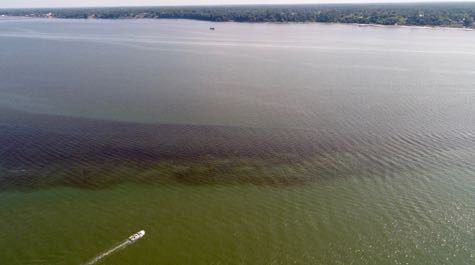
Aerial drones deliver sweet spot for HAB research at VIMS��ͼ��
aerial drones sweet spot hab research vims
2017/9/19
Harmful algal blooms or HABs are notoriously difficult to sample. They can appear abruptly when growing conditions are right, and disappear just as quickly when conditions deteriorate. They also shift...
THE POTENTIAL OF LIGHT LASER SCANNERS DEVELOPED FOR UNMANNED AERIAL VEHICLES �C THE REVIEW AND ACCURACY
UAV laser scanning light scanners accuracy review LiDAR
2016/10/14
Modern photogrammetry and remote sensing have found small Unmanned Aerial Vehicles (UAVs) to be a valuable source of data in various branches of science and industry (e.g., agriculture, cultural herit...
ACCURACY OF MEASUREMENTS IN OBLIQUE AERIAL IMAGES FOR URBAN ENVIRONMENT
Aerial Oblique Images Accuracy Urban Mapping
2016/10/14
Oblique aerial images have been a source of data for urban areas for several years. However, the accuracy of measurements in oblique images during this time has been limited to a single meter due to t...
SEMI-AUTOMATED APPROACH FOR MAPPING URBAN TREES FROM INTEGRATED AERIAL LiDAR POINT CLOUD AND DIGITAL IMAGERY DATASETS
Extraction Integrated Airborne LiDAR Multispectral Image Urban Trees
2016/10/14
Mapping of trees plays an important role in modern urban spatial data management, as many benefits and applications inherit from this detailed up-to-date data sources. Timely and accurate acquisition ...
Automated DEM extraction in digital aerial photogrammetry: precisions and validation for mass movement monitoring
digital photogrammetry automatic processing DEM precision monitoring
2015/9/10
Automated procedures for photogrammetric image processing and Digital Elevation Models (DEM) extraction
yield high precision terrain models in a short time, reducing manual editing; their accuracy is...
Aerial inventory of surficial geological effects induced by the recent Emilia earthquake (Italy): preliminary report
Earthquake Liquefaction Geological effects Aerial survey
2015/8/26
As a consequence of the two main shocks that recently struck the central alluvial Po Plain (May 20, 2012, Ml 5.9, and May 29, 2012, Ml 5.8), a great number of surficial geologic disturbances appeared ...
USING INDIVIDUAL TREE CROWN APPROACH FOR FOREST VOLUME EXTRACTION WITH AERIAL IMAGES AND LASER POINT CLOUDS
Individual Tree Crown (ITC) Laser scanning Tree height Aerial imagery Segmentation
2015/8/13
The objective of this paper is to improve the cost-effectiveness (accuracy of estimates versus applied costs) of present ITC
(Individual Tree Crown) approaches which are based on 1) aerial imagery or...
EFFICIENT INTEGRATION OF AERIAL AND TERRESTRIAL LASER DATA FOR VIRTUAL CITY MODELING USING LASERMAPS
Terrestrial Aerial Laser scanning Integration Georeferencing Registration
2015/8/13
One of the first steps during evaluation of terrestrial LIDAR measurement is the co-registration of the data sets, which are collected
from different stations and their transformation to a suitable ...
REGISTRATION OF AIRBORNE LASER DATA WITH ONE AERIAL IMAGE
Airborne Laser Scanner Data Aerial Image,
2015/6/1
At present, the calibration of airborne laser scanner data relies on the estimation of the position and attitude of the aircraft during the
acquisition using GPS and INS systems, but also on the esti...
A NEW APPROACH TO AUTOMATIC JUNCTION OF OVERLAPPING AERIAL IMAGERY DATA
Automation matching recognition, detection
2015/6/1
The original approach to image matching is proposed. The method itself can be classified as relational matching, bases on point
features. For robust extraction and filtration of features the special...
Comparison between high-resolution aerial imagery and lidar data classification of canopy and grass in the NESCO neighborhood, Indianapolis, Indiana
GIS Remote Sensing LiDAR Classification Canopy
2015/1/9
Urban forestry is a very important element of urban structures that can improve the environment and life quality within the urban areas. Having an accurate classification of urban forests and grass ar...
�й��о����������а�-��
- ���ڼ���...
�й�ѧ���ڿ����а�-��
- ���ڼ���...
�����ѧ���л������а�-��
- ���ڼ���...
�й���ѧ���а�-��
- ���ڼ���...
�ˡ���-ƪ
- ���ڼ���...
�Ρ���-ƪ
- ���ڼ���...
��������-ƪ
- ���ڼ���...
�������� -ƪ
- ���ڼ���...
֪ʶҪ��-ƪ
- ���ڼ���...
���ʶ�̬-ƪ
- ���ڼ���...
��������-ƪ
- ���ڼ���...
ѧ��ָ��-ƪ
- ���ڼ���...
ѧ��վ��-ƪ
- ���ڼ���...